Posted on March 25, 2024
With unpredictable electricity, rainfall and municipal water supply, South African farmers may need faith like potatoes to manage crop irrigation.
But, scientific suggestions from their smartphones to prevent under or over-watering would also help.
University of Pretoria researchers say that for the first time in South Africa, data from satellite imagery and local weather stations have been “calibrated” to inform irrigation strategies on potato farms in the western Free State. The data will be available as an app that shows simple indicators of exactly how much irrigation is needed on a particular day.
Once the technology is fully available to potato growers, it will also be fairly easy to adapt it to other crops like maize and onions and for other farming regions.
“Farmers will be benefiting directly, and also the researchers and agronomists supporting the growers,” says Alex Mukiibi, a PhD candidate at UP’s Department of Plant and Soil Sciences.
While the idea of using remote sensing (satellite images) and weather data for more precise irrigation is not new, says Mukiibi, the technology had not been properly adapted for local soil conditions, local potato varieties and local weather patterns until now.
He explains that the application of remote sensing data must be validated for any unique set of conditions, meaning that it must be checked against true measurements taken on the ground, so that farmers can trust it.
For the scientifically-minded, Mukiibi describes the technical details of this work in the journal Remote Sensing, alongside his supervisor at UP, Prof Martin Steyn, and Prof Angelinus Franke of the University of the Free State.
But for the rest of the country’s potato lovers, this advance essentially means that farmers will save on power and water costs, improving sustainability and ensuring that we can enjoy our chips and mash at a reasonable price.
“If we go out for dinner, the team has to eat chips; they cannot choose any other starch,” jokes Steyn.
“I’ve been working in this field of crop irrigation management, and on potatoes, for my whole life,” says Steyn. “Potato is a drought-sensitive crop, and it is expensive to grow, so the risk is very high. We see the negative effects of water, pumping and load shedding costs on farmers.”
In the 1970s and 1980s, says Steyn, only about 50% of potato growers were irrigating their crops, whereas now it is closer to 85%.
However, most farmers are still not using the many tools and technologies already available to enable “smart farming” because they are expensive, difficult to use for non-experts, or unavailable in a single app.
Recognising this gap, researchers like Steyn, Mukiibi and others are now working with the industry to deliver remote sensing-based crop water-use data simply and quickly to farmers’ smart devices.
Potatoes SA funded this first “ground truthing” calibration step, in which Mukiibi and his technical assistants, Nozi Radebe and Stéfan Steenekamp, collected soil and crop data directly on the ground at specific farms in the western Free State.
 Researchers install equipment to take soil and crop measurements directly on the field for the ground truthing process. (Photo: Prof Martin Steyn)
The research team then checked their ground observations against satellite images and weather data for the same time periods and locations.
The type of satellite data they use is known as “normalised difference vegetation index”, or NDVI, which essentially shows how green and healthy a field is.

An example of an NDVI satellite image showing the health and greenery of a potato field. (Photo supplied by Prof Martin Steyn)
This ground-truthing process allows them to optimise, or calibrate, the mathematical model used to directly glean crop water needs from the remote sensors and local weather station data, without requiring any ground measurements in the fields.
“We are now busy with the next phase,” says Steyn. “We’ve joined up with a fertiliser company called Yara Africa Fertilizer, and they are sponsoring this final step, where we do a final validation in a different region with independent data.”
The company already has an app that shows management information and NDVI images for individual fields. The added functionality will then be able to automatically “suck” in weather data from the closest weather station, and use that in combination with the satellite data to calculate the water use of that crop for the previous day or days.
Steyn says a network of new, local weather stations in the potato-growing Sandveld region of the Western Cape is currently being set up by a local service provider to help with this.
Of course, even this smart technology has its limitations, especially when it's cloudy. But Steyn says there are ways around this: because new satellite images and weather measurements are taken frequently, any gaps in the data will quickly fill up again to give farmers real-time, reliable information.
Mukiibi says that since embarking on this research as part of his PhD, in particular, spending time with South Africa’s potato growers, he’s come to understand what this technology will mean for the industry.
“On the farm you can see the impact it makes and the desire the growers have to help you execute your work,” he says.
“You can see they want to be involved, and they want this to work.”
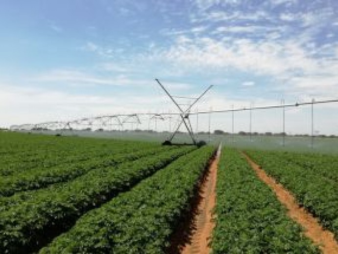
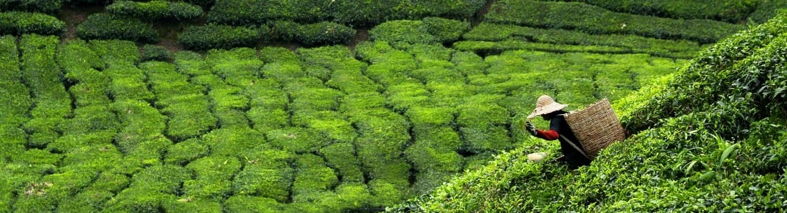
South African potato farmers rely on irrigation, but with the country’s electricity and water challenges, precise irrigation guided by science is a key part to sustain the industry. (Photo: Prof Martin Steyn)
Copyright © University of Pretoria 2025. All rights reserved.


 Virtual Campus
Get Social With Us
Download the UP Mobile App