 Story
Story
The latest issue of the University of Pretoria’s award-winning RE.SEARCH magazine is available now and reflects a shift towards both a fresher design and outlook. This edition is curated under the theme ‘Digital’, and offers a glimpse into some of the fascinating research we’re doing at UP to drive digital leadership and innovation.
 Story
Story
The articles in this edition showcase work from all nine of our faculties, and underscore our University’s slogan ‘Make today matter’. RE.SEARCH has been named South Africa's top corporate publication as the winner of the 2024 SA Publication's Forum Awards. It is a runner up and finalist in the Excellence category for Communication (runner up), Design and Photography (finalist) and the...
 Photo
Photo
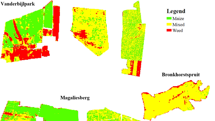
This classification map shows the different types of plants in a crop field in various areas in Gauteng. The legend shows red for weeds, green for maize and yellow for mixed growth areas.
 Infographic
Farmers not only save time and money by cutting down the cost and effort required to manage weeds, but also limit the environmental impact of using harmful weed-killing chemicals by using satellite data and imagery.
 Story
Story
In a first for precision agriculture, University of Pretoria (UP) researchers, in association with collaborators from the Council for Scientific and Industrial Research (CSIR), have produced maps of smallholder farms in Gauteng that highlight maize plants in green and weeds in red. The maps were shared with farmers to enable them to pinpoint and eradicate weeds with more precision.
 Story
Story
RE.SEARCH 9 is our most novel edition yet. In it, we have featured research that encourages us to think afresh, and is doing so, we’ve highlighted new ways of looking at research. You can expect to read about research that has potential and promise for the future but which is still nascent or represents an educated guess. This edition also features a range of multimedia that you can immerse...
Copyright © University of Pretoria 2025. All rights reserved.
Get Social With Us
Download the UP Mobile App