Professor Moses Cho became part of the University of Pretoria’s (UP) research community in 2016 when he was appointed as an extraordinary professor. He obtained his first degree in natural sciences from the University of Yaoundé in Cameroon, followed by an MSc degree from the University of Greenwich in the UK. His PhD was jointly conferred by the Netherlands-based International Institute for Geo-Information Science and Earth Observation, and Wageningen University.
Prof Cho says he conducts research at UP because it provides an enabling environment for collaboration with colleagues in his field and the supervision of postgraduate students. It also enables him to make significant contributions to the science of remote sensing, his area of specialisation.
His field of research contributes to the betterment of the world because it plays a crucial role in monitoring the impact of land use change on biodiversity and agricultural landscapes, particularly in the context of climate change. It involves utilising both airborne and spaceborne remote-sensing instruments to map landscape properties, especially in vegetated landscapes.
Within his academic discipline, Prof Cho is a leading researcher in the remote sensing of vegetated landscapes in Africa. He has served as president of the African Association of Landscape Ecology and currently heads the Precision Agricultural Research Group at the Council for Scientific and Industrial Research (CSIR).
He is also involved in several cross-faculty research initiatives, including the NEOFrontiers and Bioscape project, which focuses on developing remote-sensing capabilities to map and monitor biodiversity in the Greater Cape Floristic Region, in collaboration with various departments and external partners, including NASA. This research utilises imaging spectrometers to map the rich biodiversity of the Western Cape.
A recent milestone in his research work is the development of methodologies for biodiversity assessment in Southern African landscapes.
As for who inspires his research, he says: “Charles Darwin’s principles of the struggle for existence and survival of the fittest continue to inspire my research, guiding my approach towards safeguarding the environment.”
His academic role model is Prof Andrew Skidmore, who supervised his PhD. Prof Skidmore is the remote-sensing taskforce lead for the Group on Earth Observations Biodiversity Observation Network and the Science Advisory Committee for the European Space Agency hyperspectral CHIME satellite. He has worked at the University Twente as well as Macquarie University in Sydney, Australia.
“His mentorship has shaped my skills in formulating scientific ideas and effectively communicating them through publications and presentations,” Prof Cho says.
His dream is to transform how we monitor our environment, ensuring that everyone has access to real-time information and can act on changes in their immediate environment.
“In this way, our joined efforts will safeguard the future of our planet,” he says.
Prof Cho’s research matters because it provides the necessary data and information for evidence-based decision-making in environmental management.
He encourages aspiring researchers in his field to learn new data analytic technologies including machine learning and artificial intelligence, develop a passion for science, and be proactive in addressing environmental challenges.
When he has time, Prof Cho engages in community development initiatives, and enjoys sport, good food and dancing.
 Story
Story
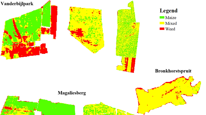
In a first for precision agriculture, University of Pretoria (UP) researchers, in association with collaborators from the Council for Scientific and Industrial Research (CSIR), have produced maps of smallholder farms in Gauteng that highlight maize plants in green and weeds in red. The maps were shared with farmers to enable them to pinpoint and eradicate weeds with more precision.
 Infographic
Farmers not only save time and money by cutting down the cost and effort required to manage weeds, but also limit the environmental impact of using harmful weed-killing chemicals by using satellite data and imagery.
 Photo
Photo
This classification map shows the different types of plants in a crop field in various areas in Gauteng. The legend shows red for weeds, green for maize and yellow for mixed growth areas.
Copyright © University of Pretoria 2025. All rights reserved.
Get Social With Us
Download the UP Mobile App