


Posted on November 02, 2016
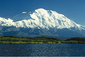
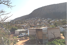
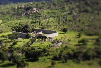
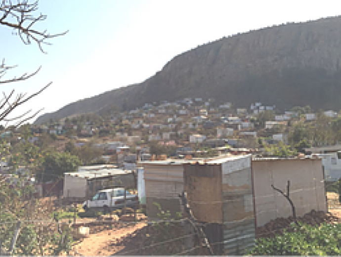
When we ponder upon Alaska, most people’s minds immediately go to the United States of America’s largest state. That Alaska state consists of lush green fields at the feet of white, snowy mountains. However, in South Africa, Alaska refers to a dry, dusty area at the foot of a mountain covered with informal dwellings instead of snow. These dwellings are constructed out of corrugated iron and other pieces of scrap metals (refer to Figure 1). Informal settlements are a common occurrence in developing countries such as South Africa. In this blog post, we will report on our experience and lessons learned from mapping the informal Alaska settlement in the City of Tshwane Metropolitan Municipality, South Africa.
 |
 |
|---|---|
| Alaska, United States of America | Alaska, City of Tshwane, South Africa |
Figure 1. The distinctive difference between the two places named, Alaska. Source
What is an informal settlement? Informal settlements are commonly defined as unplanned settlements. These settlements consist of dwellings and in South Africa they are mainly constructed out of corrugated iron and other scavenged materials. The dwellings do not comply with planning and building regulations and are therefore often deemed as unauthorised housing. Informal settlements are commonly located on the periphery of towns and cities, lacking access to most basic services such as clean water, sanitation, waste removal services and electricity supply. As a result, community members need to perform daily chores, such as collecting firewood and water from communal locations, in order to do such activities as cooking food or bathing. Electricity is generally illegally tapped from nearby formal housing. This often results in illegal and highly dangerous electrical connections. Informal settlements lack any form of formal addressing. In Alaska, for example, multiple addresses can be found on a single dwelling. A census barcode, as well as a number assigned by the community, can be found on each dwelling in the settlement (refer to Figure 2 for an example).
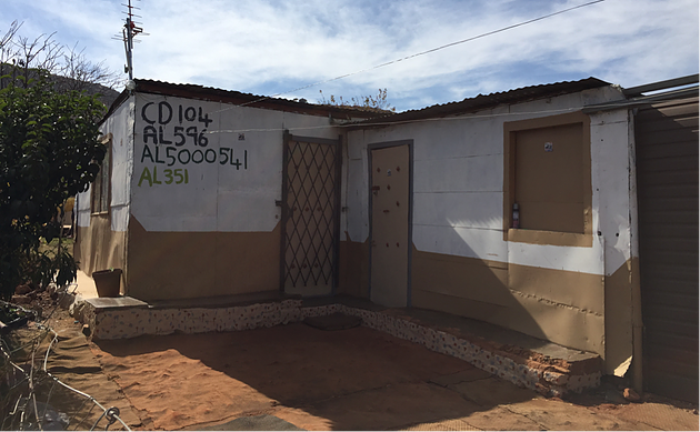
Figure 2. Dwelling with multiple dwelling numbers
How did we map this settlement? There are various ways to map informal settlements. Examples include using OpenStreetMap (OSM), unmanned aerial vehicles (UAVs) and LiDAR technology. UAV and LiDAR technologies are still quite expensive which presents a major barrier for their use. Additionally, none of the previously mentioned methods (i.e. OSM, UAV or LiDAR) could be used for mapping Alaska because without physically going out into the field, one will not be able to collect additional information such as the dwelling addresses, locations of shops or communal water points. We therefore decided to make use of handheld GPSs, as well as mobile phones. Each phone had a data collection application, EpiCollect+, preloaded onto it. Using these tools, we successfully collected 2,500 dwelling locations along with their associated addresses, locations of shops, communal water points, as well as any health hazards we came across. Collecting these 2,500 points took a full four days’ time out in the field - Phew!
What did we learn about collecting data in an informal settlement? Being engulfed within Alaska and collecting data was a great opportunity not only for implementing our knowledge of data capturing, but also for getting a glimpse into how this community functions. Some of the challenges we encountered included:
Various health hazards. One in particular that really stood out to us were the illegal electrical connections within the community. The illegal connections are currently fastened to a 2m high makeshift electricity pole while other wires run freely along footpaths and roads. These low hanging and easily trotted upon wires pose a serious health hazard to individuals collecting in-situ data, not to mention the community as a whole.
The lack of systematic, formal addresses, as well as the lack of maps overviews of the area was a major barrier towards capturing in-situ data. These hindrances made it extremely difficult to navigate through the settlement. Additional hindering factors included narrow, unmarked footpaths, as well as multiple addresses on a single dwelling.
South Africa is commonly referred to as the ‘Rainbow Nation’ due to the fact that it has 11 official languages. Alaska is an example of a settlement with individuals from all over South Africa, as well as its neighbouring African countries. The occurrence of such diverse African vernacular proved extremely challenging when trying to communicate with the community members.
Informal settlements are commonly densely populated areas with little to no space between dwellings. Using handheld GPSs and mobile phones thus proved challenging due to their accuracy levels ranging between 3-5 meters. This does not pose a major problem when collecting data in a suburb where properties are generally larger than that, but it poses a major challenge while attempting to map informal settlements where about 5 shacks (minimum) can fall within a radius of 5m.
Lastly, informal settlements are constantly growing and changing: new dwellings can pop up within a single week. Some researchers even go as far as referring to an informal settlement as a living organism. The fact that the settlement continues to grow at an exponential rate poses a problem to mapping because: how can one keep the data up-to-date? Does one spend hundreds of USA Dollars acquiring remotely sensed imagery at high temporal resolutions or does one continuously pay labourers to collect in-situ data?
Even though there are various challenges, collecting in-situ data has a number of advantages:
The needs of an individual living in an informal settlement are vastly different from that of an individual living in another urban area. In order to truly understand the needs, as well as the environment of the informal settlement, we found it most effective to emerge ourselves within it first before attempting to map it. The best way to emerge oneself in a community is by performing in-situ data collection.
Performing in-situ data collection allows for the collection of data that is not visible on aerial imagery or remotely sensed imagery. Examples include narrow footpaths, tap locations, shop locations, as well as smaller health hazards.
In-situ data collection allows for the appreciation of the little things. In Alaska, there is a strong sense of community as well as an outstanding portrayal of self-expression through art. Many dwellings in the settlement are lathered in paintings and quotes (Refer to Figure 4). Without ever physically wandering into the community, one would never be able to experience these aspects of the settlement.
Lastly, the challenges provided us with opportunities to come up with solutions that could be practically implemented. An example would be the fact that we decided to use two GPSs in order to increase the accuracy of the locational data. This was done by taking the average of the two GPSs.
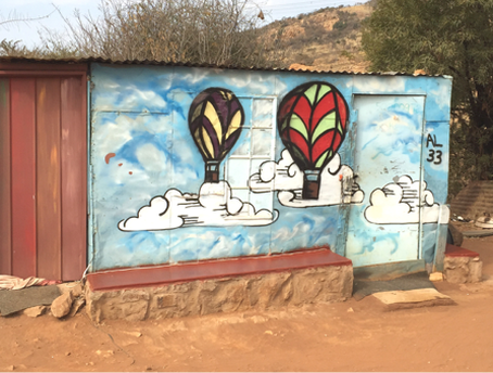
Figure 3. Example of dwellings with paintings on
What is next? The first step we took after collection the in-situ data was to clean it. This was done to ensure the best possible quality of the dataset before using it to perform further analysis and mapping. We hope to inspire empowerment within the community members of Alaska through the maps produced from this dataset. In addition, the dataset collected on the various footpaths in the settlement has been cleaned and will be uploaded and made available in OpenStreetMap.
We hope this blog has provided you with some insight into mapping informal settlements.
Happy mapping!!
This article was orignially published on the YouthMappers Blog.


Copyright © University of Pretoria 2025. All rights reserved.
 Virtual Campus
Get Social With Us
Download the UP Mobile App