


Posted on August 11, 2015
A total of forty nine (49) Grade 11 learners from all over South Africa participated in this year’s JuniorTukkie Geospatial Tech Camp. This Camp is a locally developed follow-up to the successful Global Connections and Exchange: My Community, Our Earth Tech (MyCoE) Camp that was held at the University of Pretoria in 2014.
The event was organised by JuniorTukkie, the Centre for Geoinformation Science, EIS-Africa and the South African Geography Teachers Association. The support of the sponsors – Statistics South Africa, Esri South Africa, the CSIR and the Geo-information Society of South Africa (GISSA) – has made this week possible. Learners received valuable experience and information to assist them in making informed study and career choices. Fun events, including drumming and a potjiekos competition occurred during the evenings.
The Tech Camp programme (based on MyCoE) incorporates the following: three days of training, cultural exchange, mapping and planning, hands-on sessions with geospatial technologies, designing community team projects, meeting leading industry partners, and learning basic computer literacy and essential life skills, such as study methods and time management. Learners learnt more about how to apply geospatial technologies in support of their communities. They were also well-informed about study options, bursary opportunities and careers where geospatial technologies are applied.
High school teachers and several UP students guided the learning experiences and acted as chaperones for social experiences during the week. The activities included a mix of presentations, small group discussions, lectures, interactive training sessions, simulations and role-playing, teambuilding exercises, case studies, leadership training, and social time with peers. These activities were counterbalanced with hands-on applied activities such as site visits, work in computer labs, and team-based community project design and development. The teams were given the task of identifying and solving a current and relevant problem on campus for which a map would be required. Examples included mapping noise pollution and finding a suitable site for a new residence. Learners were encouraged and guided to form scientifically derived understandings of problems and to take action, make a difference, and participate in applying solutions.
Participants were selected on the criteria that they:
At the end of the week, learners presented the projects they worked on during the week and also received feedback on their respective projects.
The JuniorTukkie Geospatial Tech Camp was concluded during an official closing ceremony where each participant received a Certificate of Attendance, presented to them by the Dean of the Faculty of Natural and Agricultural Sciences.

All participants received a Certificate of Attendance, presented to them by the Dean of the Faculty of Natural and Agricultural Sciences, Prof Jean Lubuma.
Report from Kathleen Godfrey, one of the UP students who was a chaperone during the week:
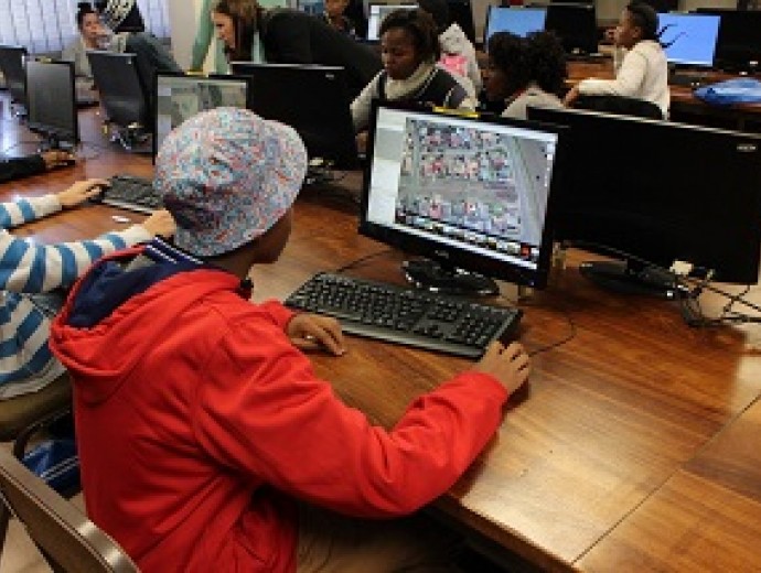
Tech Camp 2015 kicked off with some joyful noise at the amphitheatre thanks to the Roarrr team. There can be no better way to get to know your fellow camp goers than learning to ‘Coca Cola Clap’. It was a great start to a great week! The students were then lucky enough to be given access to a full online grade 11 maths and science syllabus. We had an incredible African drumming session on the first day and settled in at Altelekker, where we were greeted with a smile and a delicious dinner. The next day began with some very interesting talks on how to do presentations, careers in GIS and GIS theory, and we all got our hands on some computers for an interesting practical session on OpenStreetMap. It was really exciting to see how the information added by the students appeared on the website! That evening the Roarrr team did an awesome presentation on leadership and personal branding, which was insightful and interesting for everyone.
On Wednesday we began working on group projects. First up, each group decided on their topic, then tasks were allocated to each member and the fun began again! Data was collected on UP campus and then transformed into information which was used to solve each group’s specific issue. This was especially exciting, as it was a chance for the attending scholars to showcase their unique talents and an opportunity to work hands on with QGIS. The groups gathered their own data and created their own maps and the presentations they would be giving the next day. It was exciting to see the groups become more comfortable and enthusiastic about their projects.
Thursday was the big day. After a wonderful presentation on how some of the GISc professionals had entered into this fascinating field, it was time for presentations. All the groups presented extremely interesting topics, such as the best possible location for a new entrance on campus, and the areas on campus where the campus security program could be updated and altered. The presentations were professional and interesting, and the chaperones and facilitators were bursting with pride. That evening spirits ran high at the potjiekos competition. Each team was given a pot, wood and ingredients, and left to cook up a storm. With teams like this, who needs restaurants? The competition was great fun, and a wonderful way to round up Tech Camp 2015.
What is Geospatial Technology?
Geography is the science of place and space. Geographers ask where things are located on the surface of the earth, why they are located where they are, how places differ from one another, and how people interact with the environment. As the study of the earth’s landscapes, peoples, places and environments, it is, quite simply, about the world in which we live. Geography is unique in bridging the social sciences (human geography) with the natural sciences (physical geography). Because thinking about space and place is relevant in a variety of sciences such as economics, health, engineering, climate, plants and animals, geography is highly interdisciplinary. It is also a very appropriate perspective from which to consider complex issues, such as sustainable development, that involve economic, social, and environmental dimensions at the same time. Geographers, planners and other scientists and professionals use many technologies and techniques to learn about our world. Such geospatial technologies are increasingly used in some of the most important emerging fields for understanding our complex world. They include mobile maps, in-vehicle navigation, geographic information systems (GIS), remote sensing, earth observation, the Global Positioning System (GPS), and online maps such as Google Earth and OpenStreetMap. Geospatial technologies allow us to view, understand, question, interpret, and visualise data in many ways that reveal relationships, patterns, and trends in the form of maps, globes, reports, and charts. They assist in answering questions and solving problems by looking at data in a way that is quickly understood and easily shared. Geospatial technologies also help us to make intelligent and informed decisions about the way we live on our planet. Increasingly, geospatial technologies are also used by individuals on a daily basis – driving directions and finding the closest fast food outlet are examples.


Copyright © University of Pretoria 2025. All rights reserved.
 Virtual Campus
Get Social With Us
Download the UP Mobile App