
Within the Department of Industrial and Systems Engineering we focus on developing models that support industry and government in making decisions under uncertainty. Some example questions we aim to answer include:
What do these decisions have in common? They are all transport related. Or more generally, they deal with the mobility and accessibility of both goods and people. Why are we so interested in transport and logistics? Because we believe it is the life-giving circulatory system of a country's economy.
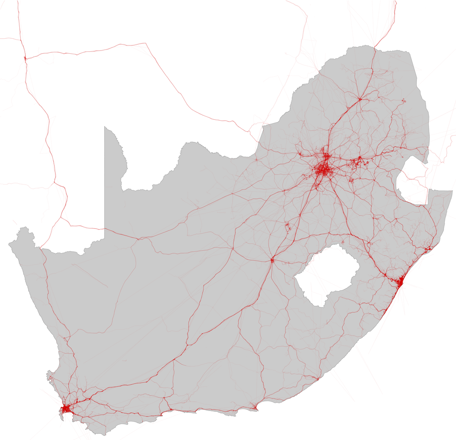
Figure 1: A single day's GPS traces of commercial vehicles across South Africa.
We subscribe to evidence-based decision-making. One cannot always follow a trial-and-error approach in practice. Instead, we employ models. Here we can entertain a variety of what-if scenarios and ensure rigorous analyses and evaluation before implementing the decision in the real world.
The following are some of the current projects we are involved in.
The Multi-Agent Transport Simulation (MATSim) toolkit provides a framework to implement large-scale agent-based transport simulations. MATSim is free and open source under the GNU General Public License version 2.0 (GPLv2). Since 2007 the Department of Industrial and Systems Engineering has worked on rolling out agent-based transport modelling in South Africa.
As part of the research project titled `Mobility Modelling using an Affordability Index', sponsored by National Treasury, we are committed to make the state of the art in transport research available to all South African stakeholders. During 2014, sample data for nine metropolitan areas were releasedin the public domain. The procedures were susequently refined and here is a link to the write-up of the new data sets, which are available online at Mendeley.
If you find any portions of the road network missing in an area, become a contributor by adding the missing bits in OpenStreetMap, and letting us know. You can find guidelines here on how to tag the road network in South Africa.
Ready to start using MATSim, follow the training videos available on YouTube. And remember to subscribe so that you are informed whenever new training videos are uploaded.
Within the Centre we assist transit authorities to capture, maintain, and host their GTFS feeds for the different transit services. This allows the routes and schedules to be available on, for example, GoogleMaps. The GTFS (latest) feeds will be made available here as and when updated.
Waste management is an important basic service provided by local municipalities and consists of the effective management of waste from its creation to its final disposal. The scale at which it is performed makes it complex and costly, with local government spending in excess of R10 billion on the function per annum. Improving waste management is challenging due to the budgetary constraints of local government, which results in this function having to compete with other basic service delivery functions, such as water, sanitation and electricity, for investments and resources. It is therefore critical that the function optimally uses its available resources to best provide the service, and correctly plan for the future delivery of the service.
Waste collection is transport intensive since waste is continuously collected at points of origin and transported via road to landfill sites. Within the Centre we have developed models to assist local government to better plan and operate the waste collection function.
The following video presentation deals with the topic of overcoming data challenges for waste management in developing cities, and was presented by Dr Elias J. Willemse at the Smart & Sustainable Cities and Transport Seminar, hosted at the CSIR Pretoria Site, in Pretoria, South Africa from 12 to 14 July 2017.
The presentation covers our research work on using GPS records of waste collection vehicles to accurately analyse waste collection operations. The benefits of our approach are that it uses existing data sources; it is a bottom-up approach, and therefore produces accurate data on a micro/miso scale; it’s automated and scalable, and can therefore be applied to entire cities, and it’s easy to continuously maintain.
Copyright © University of Pretoria 2025. All rights reserved.
 Virtual Campus
Get Social With Us
Download the UP Mobile App